Iowa Crops and Weather Report- 7/1/19

DES MOINES, Iowa (July 1, 2019) – Iowa Secretary of Agriculture Mike Naig today commented on the Iowa Crop Progress and Condition report released by the USDA National Agricultural Statistics Service. The report is released weekly from April through November.
“The much needed warmer temperatures have helped the crops progress,” said Secretary Naig. “Some parts of the state had below-average rainfall over the last seven days, but sub-soil moisture is still adequate for the crops to grow.”
The weekly report is also available on the USDA’s site at nass.usda.gov/ia.
Crop Report
Iowa experienced scattered storms across the state that delivered high winds and hail, limiting opportunities for fieldwork during the week ending June 30, 2019, according to the USDA, National Agricultural Statistics Service. Statewide there were 4.4 days suitable for fieldwork. Fieldwork activities included planting, harvesting hay and spraying.
Topsoil moisture condition was rated 0 percent very short, 2 percent short, 74 percent adequate and 24 percent surplus. Subsoil moisture condition was rated 0 percent very short, 1 percent short, 69 percent adequate and 30 percent surplus.
Corn condition improved to 64 percent good to excellent. Soybean planting has nearly finished with 97 percent of the expected soybean crop planted. Ninety percent of the crop has emerged, over two weeks behind the 5-year average, and one percent has started to bloom. Soybean condition rated 64 percent good to excellent, also an improvement from last week.
Seventy-nine percent of the oat crop has headed, 8 days behind last year and average. Nine percent of the crop has started coloring, nearly a week behind average. Oat condition rated 64 percent good to excellent.
Eighty-three percent of the first cutting of alfalfa hay has been cut, two weeks behind average. Reports that a second cutting of alfalfa hay has also began across the state. Hay condition declined to 63 percent good to excellent. Pasture condition rated 70 percent good to excellent. Livestock experienced some stress with the recent heat. Feedlots remain muddy but have started to improve.
Weather Summary
Provided by Justin Glisan, Ph.D., State Climatologist, Iowa Department of Agriculture and Land Stewardship
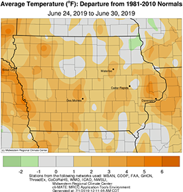
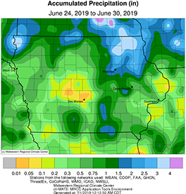
Unseasonably dry conditions were reported across a majority of the state with locations across northern Iowa observing above average rainfall; west-central Iowa experienced rainfall deficits over an inch below normal. Unseasonable warmness also returned to the state over the reporting period with the average temperature 2.50 degrees above the normal of 73.0 degrees.
A low pressure system and attendant cold front propagated across Iowa on Sunday (23rd), producing showers and thunderstorms. Partly to mostly cloudy conditions prevailed across the state with highs only reaching into the low to mid 70s. Rainfall totals at 7 a.m. on Monday (24th) ranged from 0.01 inches in Sioux City (Woodbury County) to 2.22 inches in Ringsted (Emmet County).
Tuesday (25th) was an active weather day for Iowa’s southern half. Thunderstorms began to pop up in the early afternoon hours with some becoming severe. Thunderstorms continued to form over this region into the nighttime hours. There were multiple reports of hail across nine counties with Murray (Clarke County) reporting a 2.00 inch hailstone. There were also a few reports of severe straight-line winds causing tree damage from Decatur to Davis counties. Rainfall totals were in the general range of 0.25 to 1.00 inches across the southern third of Iowa. Locally heavy rain also accompanied some of these thunderstorms; Creston (Union County) reported 1.92 inches, 1.78 inches above average. Thunderstorm activity continued across western Iowa into Wednesday (26th) until the system dissipated around midday. Skies cleared allowing highs to reach into the low to mid 80s.
Strong thunderstorms, some of which turned severe, moved across northern Iowa during the early morning hours of Thursday (27th). Multiple occurrences of severe straight-line winds and large hail were reported from Sioux County to Jones County. Locally heavy rain totals were also observed. Thirteen stations reported rainfall above two inches with New Hampton (Chickasaw County) observing 3.52 inches, 3.34 inches above normal. High temperatures across the northern third of Iowa stayed in the low to mid 70s where clouds and rain were present. The rest of the state saw temperatures in the upper 80s and low 90s, four to five degrees above average.
A large swath of east-central Iowa experienced thunderstorms on Friday (28th) as a mesoscale convective system (MCS) moved south from Minnesota. The storms intensified as they moved into southern Iowa, producing downpours and severe straight-line wind reports from Marion County to Des Moines County; 11 counties had high wind reports with minor tree and/or structural damage. Bloomfield (Davis County) also reported quarter-sized hail. Much of eastern Iowa observed measurable rain with totals along the path of the MCS between 0.50 and 1.00 inch. Eight stations reported totals over an inch with Albia (Monroe County) observing 1.68 inches.
Saturday (29th) was the warmest day of the year statewide with average highs in the low 90s across northeastern Iowa and mid to upper 90s across the rest of the state; the average high was 95 degrees, eight degrees above average. Isolated thunderstorms popped up in eastern Iowa, leaving behind 1.14 inches in Dubuque (Dubuque County). Overnight lows into Sunday (30th) remained well above average under generally clear skies. Under light southerly winds, the average low was 71 degrees, nine degrees above normal statewide.
Weekly rainfall totals ranged from 0.01 inches in Des Moines (Polk County) to 4.27 inches in Creston (Union County). The statewide weekly average precipitation was 0.95 inches, while the normal is 1.16 inches. The week’s high temperature of 98 degrees was observed in Little Sioux (Harrison County) and Mapleton (Monona County) on the 29th, 13 degrees above normal. Cresco (Howard County) reported the week’s low temperature of 53 degrees on the 26th, five degrees below average.


