Severe Weather Update — 8:20 PM
819 PM CDT Mon Aug 5 2019
…A SEVERE THUNDERSTORM WARNING REMAINS IN EFFECT UNTIL 845 PM CDT FOR NORTHEASTERN WRIGHT…SOUTHEASTERN HANCOCK AND SOUTHWESTERN CERRO GORDO COUNTIES…
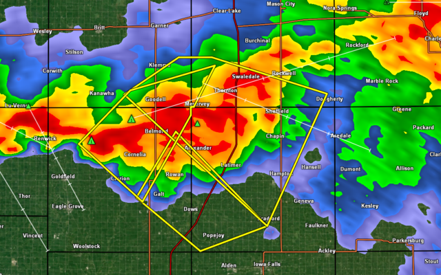
At 819 PM CDT, a severe thunderstorm was located over Belmond, or 11 miles northeast of Clarion, moving southeast at 30 mph.
HAZARD…60 mph wind gusts.
SOURCE…Radar indicated.
IMPACT…Expect damage to roofs, siding, and trees.
Locations impacted include…
Clarion, Belmond, Elm Lake, Meservey, Goodell, Belmond Municipal Airport and Clarion Municipal Airport.
811 PM CDT Mon Aug 5 2019
…A SEVERE THUNDERSTORM WARNING REMAINS IN EFFECT UNTIL 845 PM CDT FOR NORTHEASTERN WRIGHT…FRANKLIN…SOUTHEASTERN HANCOCK AND SOUTHERN CERRO GORDO COUNTIES…
At 811 PM CDT, a severe thunderstorm was located 9 miles west of Sheffield, or 13 miles northwest of Hampton, moving southeast at 35 mph.
HAZARD…60 mph wind gusts. A trained weather spotter near Meservey estimated wind gusts of 50 mph around 8:07 pm.
SOURCE…Radar indicated.
IMPACT…Expect damage to roofs, siding, and trees.
Locations impacted include…
Hampton, Belmond, Sheffield, Rockwell, Latimer, Thornton, Coulter, Meservey, Alexander, Swaledale, Goodell, Bradford, Chapin, Beeds Lake State Park, Hampton Municipal Airport and Belmond Municipal Airport.
This includes Interstate 35 between mile markers 165 and 184.
807 PM CDT Mon Aug 5 2019
The National Weather Service in Des Moines has issued a
* Severe Thunderstorm Warning for…
East central Wright County in north central Iowa…
Southwestern Franklin County in north central Iowa…
* Until 845 PM CDT.
* At 807 PM CDT, a severe thunderstorm was located near Belmond, or 12 miles northeast of Clarion, moving southeast at 30 mph.
HAZARD…60 mph wind gusts.
SOURCE…Radar indicated.
IMPACT…Expect damage to roofs, siding, and trees.
* Locations impacted include…
Dows, Alexander, Rowan, Popejoy and Galt.
This includes Interstate 35 between mile markers 154 and 165.