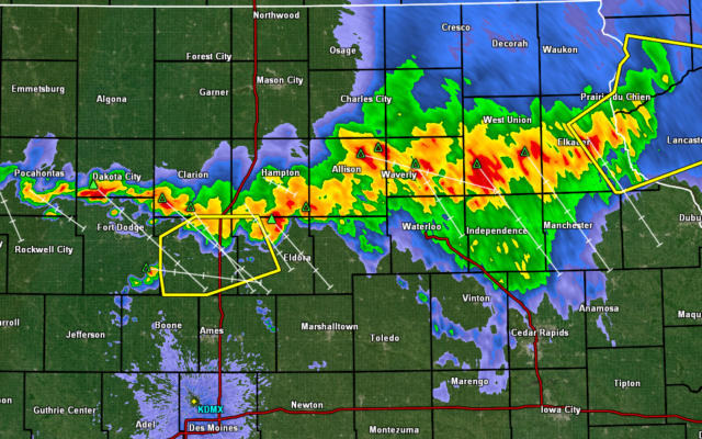
Severe Weather Update — Monday August 5th — 9:15 PM update
Wright IA-Franklin IA-
910 PM CDT Mon Aug 5 2019
…THE SEVERE THUNDERSTORM WARNING FOR SOUTHERN WRIGHT AND SOUTHWESTERN FRANKLIN COUNTIES IS CANCELLED…
The storms which prompted the warning have moved out of the warned area. Therefore, the warning has been cancelled.
A Severe Thunderstorm Watch remains in effect until 1100 PM CDT for central and north central Iowa.
There are currently no warnings in our immediate listening area
905 PM CDT Mon Aug 5 2019
…THE SEVERE THUNDERSTORM WARNING FOR NORTHEASTERN HARDIN…EAST
CENTRAL WRIGHT…FRANKLIN…NORTHWESTERN GRUNDY AND BUTLER COUNTIES
WILL EXPIRE AT 915 PM CDT…
The storms which prompted the warning have moved out of the area.
Therefore, the warning will be allowed to expire. However gusty
winds are still possible with these thunderstorms.
A Severe Thunderstorm Watch remains in effect until 1100 PM CDT for
central and north central Iowa.
858 PM CDT Mon Aug 5 2019
The National Weather Service in Des Moines has issued a
* Severe Thunderstorm Warning for…
Western Hardin County in central Iowa…
Southern Wright County in north central Iowa…
Southwestern Franklin County in north central Iowa…
Hamilton County in central Iowa…
* Until 930 PM CDT.
* At 857 PM CDT, severe thunderstorms were located along a line
extending from 9 miles east of Big Wall Lake to near Webster City,
moving south at 45 mph.
HAZARD…60 mph wind gusts.
SOURCE…Trained weather spotters. At 8:55pm, a trained weather
spotter 5 miles southwest of Woolstock reported a 60 mph
wind gust.
IMPACT…Expect damage to roofs, siding, and trees.
* Locations impacted include…
Webster City, Jewell Junction, Big Wall Lake, Hubbard, Alden,
Stratford, Radcliffe, Dows, Ellsworth, Stanhope, Williams,
Blairsburg, Kamrar, Randall, Woolstock, Buckeye, Popejoy, Galt,
Webster City Municipal Airport and Drake Airport.
This includes Interstate 35 between mile markers 129 and 163.
PRECAUTIONARY/PREPAREDNESS ACTIONS…
For your protection move to an interior room on the lowest floor of a
building.
&&
FROM KGLO NEWS — 8:55 PM — These counties cleared from Severe Thunderstorm Watches — Cerro Gordo, Hancock, Kossuth, Winnebago, Worth, Mitchell, Mower. Still in effect for all other counties in listening area
844 PM CDT Mon Aug 5 2019
…A SEVERE THUNDERSTORM WARNING REMAINS IN EFFECT UNTIL 915 PM CDT
FOR NORTHEASTERN HARDIN…EAST CENTRAL WRIGHT…FRANKLIN…
NORTHWESTERN GRUNDY AND BUTLER COUNTIES…
At 843 PM CDT, severe thunderstorms were located along a line
extending from 10 miles northwest of Allison to near Ackley to 6
miles north of Iowa Falls to 11 miles southwest of Hampton, moving
southeast at 40 mph.
HAZARD…60 mph wind gusts.
SOURCE…Radar indicated. The Hampton Airport reported a 43 mph wind
gust at 8:35pm.
IMPACT…Expect damage to roofs, siding, and trees.
Locations impacted include…
Iowa Falls, Hampton, Allison, Parkersburg, Ackley, Clarksville,
Sheffield, Aplington, Alden, Dumont, Dows, Latimer, Coulter,
Alexander, Geneva, Bristow, Rowan, Bradford, Hansell and Chapin.
This includes Interstate 35 between mile markers 153 and 175.
PRECAUTIONARY/PREPAREDNESS ACTIONS…
For your protection move to an interior room on the lowest floor of a
building.
838 PM CDT Mon Aug 5 2019
IAC079-091-187-197-060200-
/O.CON.KDMX.SV.W.0170.000000T0000Z-190806T0200Z/
Webster IA-Wright IA-Humboldt IA-Hamilton IA-
838 PM CDT Mon Aug 5 2019
…A SEVERE THUNDERSTORM WARNING REMAINS IN EFFECT UNTIL 900 PM CDT
FOR NORTHEASTERN WEBSTER…SOUTHERN WRIGHT…SOUTHEASTERN HUMBOLDT
AND NORTHWESTERN HAMILTON COUNTIES…
At 837 PM CDT, a severe thunderstorm was located over Eagle Grove, or
10 miles west of Clarion, moving southeast at 45 mph.
HAZARD…60 mph wind gusts.
SOURCE…Trained weather spotters. At 8:35pm, trained weather
spotters 2 miles north of Eagle Grove reported a 60 mph
wind gust.
IMPACT…Expect damage to roofs, siding, and trees.
Locations impacted include…
Clarion, Eagle Grove, Big Wall Lake, Goldfield, Duncombe, Thor,
Vincent, Woolstock, Eagle Grove Municipal Airport, Sportsman Park and
Clarion Municipal Airport.
This includes Interstate 35 between mile markers 150 and 153.
PRECAUTIONARY/PREPAREDNESS ACTIONS…
For your protection move to an interior room on the lowest floor of a
building.