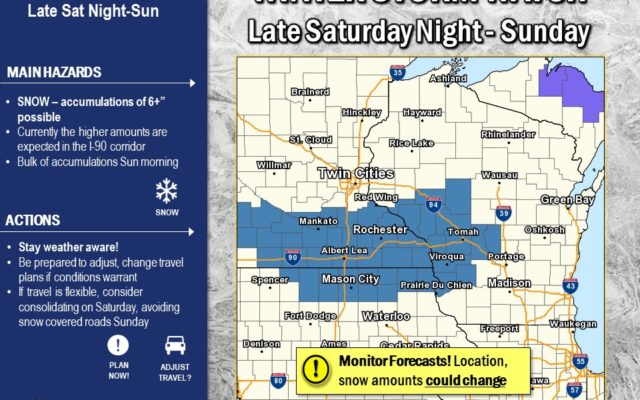
Winter Storm Watch for north-central Iowa late Saturday night into Sunday
For the latest details click here
A winter storm is expected to impact portions of northern Iowa Saturday night and Sunday. This system will bring the potential for moderate to locally heavy snow fall. The greatest snowfall amounts are expected to be along and north of the Iowa and Minnesota border. In addition, increasing northerly winds will create some blowing and drifting of snow.
Emmet-Kossuth-Winnebago-Worth-Hancock-Cerro Gordo-
Including the cities of Estherville, Algona, Forest City, Lake Mills, Northwood, Manly, Garner, Britt, Kanawha, Mason City, and Clear Lake
325 AM CST Fri Feb 7 2020
…WINTER STORM WATCH IN EFFECT FROM LATE SATURDAY NIGHT THROUGH SUNDAY AFTERNOON…
* WHAT…Moderate to locally heavy snowfall. Brief period of icing may occur. Total snow accumulations of 4 to 6 inches and ice accumulations of a light glaze possible. Some blowing and drifting of snow may occur.
* WHERE…Portions of northern Iowa.
* WHEN…From late Saturday night into Sunday.
* IMPACTS…Travel could be very difficult.
PRECAUTIONARY/PREPAREDNESS ACTIONS…
Monitor the latest forecasts for updates on this situation.
=========
Mitchell-Howard-Winneshiek-Allamakee-Floyd-Chickasaw-Wabasha- Dodge-Olmsted-Winona-Mower-Fillmore-Houston-
Including the cities of Osage, Cresco, Decorah, Waukon, Charles City, New Hampton, Wabasha, Dodge Center, Rochester, Winona, Austin, Preston, and Caledonia
237 AM CST Fri Feb 7 2020
…WINTER STORM WATCH IN EFFECT FROM LATE SATURDAY NIGHT THROUGH
SUNDAY AFTERNOON…
* WHAT…Snow. Brief period of wintry mix possible. Snow accumulations of 4 to 7 inches and ice accumulations of a light glaze possible.
* WHERE…Portions of north central and northeast Iowa and southeast Minnesota.
* WHEN…From late Saturday night through Sunday afternoon.
* IMPACTS…Travel could be very difficult.