WINTER STORM WATCH — Late season storm likely to impact our listening area
These are the Winter Storm Watch statements from the National Weather Service as issued earlier this morning. For further updates click here.
Iowa Road Conditions link
Minnesota Road Conditions link
Late Season Winter Storm to Impact Area Saturday…
.A fast moving and windy storm system will bring a narrow band of
wet, heavy snow to portions of northern Iowa Saturday. The snow
may melt on contact at the start of the event, but quickly begin
to accumulate through the morning hours with snowfall rates of 1
to 2 inches per hour at times. North northeast at 20 to 35 mph may
significantly reduce visibility and make for hazardous travel.
IAZ004>007-016-017-026>028-261700-
/O.NEW.KDMX.WS.A.0006.190427T1200Z-190428T0000Z/
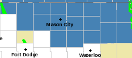
Emmet-Kossuth-Winnebago-Worth-Hancock-Cerro Gordo-Franklin-Butler-
Bremer-
Including the cities of Estherville, Algona, Forest City,
Lake Mills, Northwood, Manly, Garner, Britt, Kanawha, Mason City,
Clear Lake, Hampton, Parkersburg, Clarksville, Shell Rock,
Greene, Aplington, Allison, Dumont, and Waverly
400 AM CDT Fri Apr 26 2019
…WINTER STORM WATCH IN EFFECT FROM SATURDAY MORNING THROUGH
SATURDAY EVENING…
* WHAT…Heavy snow possible. Total snow accumulations of up to 3
to 6 inches with locally higher amounts possible. Winds could
gust as high as 35 to 40 mph.
* WHERE…Portions of North Central and Northeast Iowa.
* WHEN…From Saturday morning through Saturday evening.
* ADDITIONAL DETAILS…Travel could be very difficult.
PRECAUTIONARY/PREPAREDNESS ACTIONS…
A Winter Storm Watch means there is potential for significant
snow, sleet or ice accumulations that may impact travel. Continue
to monitor the latest forecasts.
===================================
Mitchell-Howard-Winneshiek-Allamakee-Floyd-Chickasaw-Fayette-
Clayton-Wabasha-Dodge-Olmsted-Winona-Mower-Fillmore-Houston-
La Crosse-Vernon-Crawford-Richland-Grant-
Including the cities of Osage, Cresco, Decorah, Waukon,
Charles City, New Hampton, Oelwein, Elkader, Wabasha,
Dodge Center, Rochester, Winona, Austin, Preston, Caledonia,
La Crosse, Viroqua, Prairie Du Chien, Richland Center,
and Platteville
402 AM CDT Fri Apr 26 2019
…WINTER STORM WATCH IN EFFECT FROM SATURDAY MORNING THROUGH
SATURDAY EVENING…
* WHAT…Heavy snow possible. Total snow accumulations of 4 to 9
inches possible. Winds could gust as high as 35 mph.
* WHERE…Portions of southwest and west central Wisconsin, northeast
Iowa, and southeast Minnesota.
* WHEN…From Saturday morning through Saturday evening.
* ADDITIONAL DETAILS…Travel could be very difficult.
PRECAUTIONARY/PREPAREDNESS ACTIONS…
A Winter Storm Watch means there is potential for significant
snow, sleet or ice accumulations that may impact travel. Continue
to monitor the latest forecasts.
===================================
Le Sueur-Rice-Goodhue-Blue Earth-Waseca-Steele-Martin-Faribault-
Freeborn-
Including the cities of Le Sueur, Faribault, Red Wing, Mankato,
Waseca, Owatonna, Fairmont, Blue Earth, and Albert Lea
315 AM CDT Fri Apr 26 2019
…WINTER STORM WATCH IN EFFECT FROM SATURDAY MORNING THROUGH
SATURDAY EVENING…
* WHAT…Heavy snow possible. Total snow accumulations of 3 to 8
inches possible.
* WHERE…Portions of south central and southeast Minnesota.
* WHEN…From Saturday morning through Saturday evening.
* ADDITIONAL DETAILS…East to northeast winds of 10 to 20 mph
with gusts to 30 mph are expected. Travel could be very
difficult.
PRECAUTIONARY/PREPAREDNESS ACTIONS…
A Winter Storm Watch means there is potential for significant
snow, sleet or ice accumulations that may impact travel. Continue
to monitor the latest forecasts.