BLIZZARD WARNING for Cerro Gordo, Hancock, Worth, Winnebago, Kossuth counties this afternoon, evening
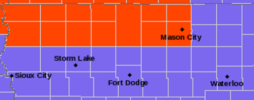
MASON CITY — A Blizzard Warning will be in effect this afternoon through midnight tonight for Cerro Gordo, Hancock, Worth, Winnebago, Kossuth counties. A Winter Weather Advisory is in effect for our listening area as well. Here are the details as of 5:15 this morning, along with some important links for you to check throughout the day
Latest from the National Weather Service
Strong northwest winds will develop by midday Thursday causing
blizzard conditions over northern Iowa this afternoon into this
evening. In the southeast, there is a potential for tree damage
and power outages where significant ice accumulation occurs.
Hazardous driving conditions are expected over much of the region
today into this evening.

Another round of bitter cold wind chills arrives late today into
Friday morning. Wind Chill Advisories and Warnings will be needed
over much of central Iowa.
Emmet-Kossuth-Winnebago-Worth-Hancock-Cerro Gordo-
Including the cities of Estherville, Algona, Forest City,
Lake Mills, Northwood, Manly, Garner, Britt, Kanawha, Mason City,
and Clear Lake
401 AM CST Thu Feb 7 2019

...WINTER WEATHER ADVISORY NOW IN EFFECT UNTIL NOON CST TODAY...
...BLIZZARD WARNING IN EFFECT FROM NOON TODAY TO MIDNIGHT CST
TONIGHT...

* WHAT...Mixed precipitation. Blizzard conditions expected. Total
  snow accumulations of 1 to 2 inches expected with ice
  accumulations of a light glaze. Winds gusting as high as 45 mph.

* WHERE...Northern Iowa.

* WHEN...For the Blizzard Warning, from noon today to midnight
  CST tonight. For the Winter Weather Advisory, until noon CST
  today.

* ADDITIONAL DETAILS...Plan on slippery road conditions.
  Widespread blowing snow will significantly reduce visibility,
  particularly in rural areas. The hazardous conditions will
  impact today`s commute. Dangerously cold wind chills as low as
  35 below zero are expected later this afternoon into Friday
  morning, which could cause frostbite on exposed skin in as
  little as 10 minutes.

PRECAUTIONARY/PREPAREDNESS ACTIONS...

A Blizzard Warning means severe winter weather conditions are
expected or occurring. Falling and blowing snow with strong winds
and poor visibilities are likely. This will lead to whiteout
conditions, making travel extremely dangerous. Do not travel. If
you must travel, have a winter survival kit with you. If you get
stranded, stay with your vehicle.

The latest road conditions for the state you are calling from can
be obtained by calling 5 1 1.

===============
Mitchell-Howard-Winneshiek-Allamakee-Floyd-Chickasaw-Fayette-
Clayton-
Including the cities of Osage, Cresco, Decorah, Waukon,
Charles City, New Hampton, Oelwein, and Elkader
331 AM CST Thu Feb 7 2019

...WINTER WEATHER ADVISORY NOW IN EFFECT UNTIL MIDNIGHT CST
TONIGHT...

* WHAT...A wintry mix of freezing rain, snow, and sleet changing
  to all snow. Snow accumulations of 2 to 4 inches and ice
  accumulations of up to one tenth of an inch. Winds gusting as
  high as 45 mph this afternoon.

* WHERE...Portions of north central and northeast Iowa.

* WHEN...Until midnight CST tonight.

* ADDITIONAL DETAILS...Plan on slippery road conditions. Blowing
  snow could significantly reduce visibility. The hazardous
  conditions could impact the morning or evening commute. Cold
  wind chills as low as 30 below zero could cause frostbite on
  exposed skin in as little as 30 minutes late this afternoon
  through tonight.

PRECAUTIONARY/PREPAREDNESS ACTIONS...

A Winter Weather Advisory means that periods of snow, sleet or
freezing rain will cause travel difficulties. Expect slippery
roads and limited visibilities, and use caution while driving.

The latest road conditions for Iowa can be found on-line at
511ia.org, in Minnesota at 511mn.org, and in Wisconsin at
511wi.gov or by calling 5 1 1.