Iowa Crop Progress and Conditions Report- 7/29/19

DES MOINES, Iowa (July 29, 2019) – Iowa Secretary of Agriculture Mike Naig today commented on the Iowa Crop Progress and Conditions report released by the USDA National Agricultural Statistics Service. The report is released weekly from April through November.
“Farmers across most of the state enjoyed several days of near-perfect weather last week,” said Secretary Naig. “Corn development is in various stages. The earliest planted corn is almost done pollinating, while some fields that were delayed because of wet spring conditions are just starting to tassel.”
The weekly report is also available on the USDA’s site at nass.usda.gov/ia.
Crop Report
This past week brought below average temperatures and little to no rain across much of the state as Iowa farmers had 5.9 days suitable for fieldwork during the week ending July 28, 2019, according to the USDA, National Agricultural Statistics Service. Fieldwork activities included scouting, spraying fungicides and insecticides, and harvesting hay and oats.
Topsoil moisture condition was rated 4 percent very short, 21 percent short, 71 percent adequate and 4 percent surplus. Districts in the southern third of Iowa and the east central district reported topsoil moisture conditions as over 40 percent short to very short. Some counties within those districts were also rated as abnormally dry for the first time this season according to the July 25, 2019, U.S. Drought Monitor. Subsoil moisture condition was rated 2 percent very short, 14 percent short, 79 percent adequate and 5 percent surplus.
Sixty-nine percent of the corn crop has begun to silk, 13 days behind last year and 8 days behind the 5-year average. Seven percent of the crop reached the dough stage, nearly one week behind both last year and average. Corn condition rated 65 percent good to excellent.
Sixty-five percent of the soybean crop has started to bloom, 13 days behind last year and 10 days behind average. Thirteen percent of the crop has started setting pods, nearly two weeks behind average. Soybean condition rated 62 percent good to excellent.
Ninety-four percent of oats started coloring, 2 days behind last year and average. Thirty-nine percent of the oat crop has been harvested for grain, 6 days behind average. Oat condition rated 63 percent good to excellent. The second cutting of alfalfa hay reached 76 percent, 6 days behind average. A third cutting of alfalfa hay has started with 2 percent complete statewide. Hay condition rated 62 percent good to excellent. Pasture condition declined for the fourth straight week with 56 percent good to excellent. Cooler temperatures this past week helped improve livestock conditions.
Weather Summary
Provided by Justin Glisan, Ph.D., State Climatologist, Iowa Department of Agriculture and Land Stewardship
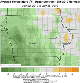
Iowa experienced a less active weather pattern during the reporting period with multiple days in which rainfall was largely absent from the state. With less thunderstorm activity, unseasonable dryness was reported across the state. Cooler than normal conditions also prevailed with average temperatures up to five degrees below normal in western Iowa. The statewide average temperature was 71.9 degrees, 1.5 degrees below normal.
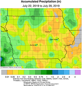
Showers and isolated thunderstorms pushed out of Iowa through the rest of Sunday (21st) and into the overnight hours. Light but measurable rain fell across parts of western and southern Iowa, where totals were highest; Red Oak (Montgomery County) reported 0.32 inches while Rathbun Dam reported 0.18 inches. High temperatures were generally in the 70s with a statewide average high of 78 degrees, six degrees below normal.
Unseasonably cool temperatures continued into Monday (22nd) under clear conditions and northerly flow. Dry conditions also prevailed as high pressure dominated. Overnight lows into Tuesday (23rd) dipped into the mid-50s, up to 12 degrees cooler than average. Dry and pleasant conditions continued through the day under partly cloudy skies. Highs reached the upper 70s and low 80s, continuing the unseasonable coolness; there were no reports of measurable rainfall. Wednesday (24th) was a rain-free day across the state as temperatures started to approach more seasonal values; eastern Iowa reported highs in the mid-80s while western Iowa was two to four degrees below average.
Showers and a few thunderstorms moved through Iowa most of Thursday (25th) leaving measurable rainfall across the state. The highest totals were reported across northern Iowa; Rock Valley (Sioux County) observed 0.23 inches while Forest City (Winnebago County) reported 0.46 inches. West-central Iowa also picked up totals between 0.16 inches at Mapleton (Monona County) to 0.30 inches in Denison (Crawford County). Cloud cover and rainfall kept highs 10 to 15 degrees below average in northern Iowa with the average statewide temperature at 80 degrees, five degrees below normal.
Friday (26th) saw temperatures rebound with a southerly wind and clear skies. Dry conditions also prevailed into Saturday (27th) for much of the state, though a narrow band of thundershowers extended from central to eastern Iowa, generally along the I-80 corridor. The northwest quadrant of Iowa also reported showers in advance of a cold front. Rainfall totals at 7:00 am on Sunday (28th) ranged from 0.03 inches at Sioux City (Woodbury County) to 0.36 inches in Traer (Tama County). Daytime highs on Saturday were in the mid to upper 80s with a statewide average of 88 degrees, four degrees warmer than normal.
Weekly rainfall totals ranged from no accumulation at De Witt (Scott County) to 0.55 inches at Underwood (Pottawattamie County). The statewide weekly average precipitation was 0.13 inches, well below the normal of 0.97 inches. The week’s high temperature of 91 degrees was reported on the 27th in Ankeny (Polk County), Donnellson (Lee County) and Newton (Jasper County), five degrees above average. Atlantic (Cass County), Denison (Crawford County), Little Sioux (Harrison County) and Mapleton (Monona County) reported the week’s low temperature of 50 degrees on the 23rd, on average 13 degrees below average.