Snow coming to an end, but blowing & drifting snow will impact area Tuesday into Tuesday night
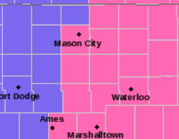
== WINTER STORM WARNING UNTIL 9:00 PM — Cerro Gordo, Franklin, Butler
== WINTER STORM WARNING UNTIL 12:00 MIDNIGHT — Floyd, Mitchell
== WINTER WEATHER ADVISORY UNTIL 9:00 PM/ORIGINAL WINTER STORM WARNING CANCELLED — Winnebago, Worth, Hancock, Wright
National Weather Service-Des Moines — latest “Situation Report”
National Weather Service-Des Moines main page
.Snow will be lifting out of the state this morning but will
linger into the afternoon over the far northeast. Morning travel
may be impacted by road crews clearing last night`s snow but
little additional accumulation is expected. Strong winds will
develop over the state beginning in the mid to late morning and
persist into the mid evening hours. The strong wind will produce
blowing and drifting snow and reduce visibility. this will mainly
impact the evening commute.

IAZ017-026>028-037>039-048>050-060>062-073>075-084>086-121800-
/O.EXT.KDMX.WS.W.0006.000000T0000Z-190213T0300Z/
Cerro Gordo-Franklin-Butler-Bremer-Hardin-Grundy-Black Hawk-Story-
Marshall-Tama-Polk-Jasper-Poweshiek-Warren-Marion-Mahaska-Lucas-
Monroe-Wapello-
Including the cities of Mason City, Clear Lake, Hampton,
Parkersburg, Clarksville, Shell Rock, Greene, Aplington, Allison,
Dumont, Waverly, Iowa Falls, Eldora, Ackley, Grundy Center,
Reinbeck, Conrad, Dike, Wellsburg, Waterloo, Cedar Falls, Ames,
Marshalltown, Tama, Toledo, Traer, Dysart, Gladbrook, Des Moines,
Newton, Grinnell, Indianola, Norwalk, Carlisle, Pella, Knoxville,
Oskaloosa, Chariton, Albia, and Ottumwa
356 AM CST Tue Feb 12 2019

...WINTER STORM WARNING NOW IN EFFECT UNTIL 9 PM CST THIS
EVENING...

* WHAT...Light snow ending this morning with less than an inch
  additional snow. Strong wind developing late morning through mid
  evening producing blowing and drifting snow and reduced
  visibility. The blowing snow will impact the evening commute.
  Winds will increase to between 20 to 25 mph with gusts near 40
  mph producing low visibilities. Areas most impacted will be
  where moderate to heavy snow fell last night and open areas.

* WHERE...Central Iowa.

* WHEN...Until 9 PM CST this evening.

* ADDITIONAL DETAILS...Travel will be very difficult. Patchy
  blowing snow could significantly reduce visibility. The
  hazardous conditions could impact the morning or evening
  commute.

PRECAUTIONARY/PREPAREDNESS ACTIONS...

A Winter Storm Warning means significant amounts of snow, sleet
and ice will make travel very hazardous.

The latest road conditions for the state you are calling from can
be obtained by calling 5 1 1.

=========
Mitchell-Howard-Winneshiek-Allamakee-Floyd-Chickasaw-Fayette-
Clayton-Dodge-Olmsted-Winona-Mower-Fillmore-Houston-Crawford-
Grant-
Including the cities of Osage, Cresco, Decorah, Waukon,
Charles City, New Hampton, Oelwein, Elkader, Dodge Center,
Rochester, Winona, Austin, Preston, Caledonia, Prairie Du Chien,
and Platteville
253 AM CST Tue Feb 12 2019

...WINTER STORM WARNING NOW IN EFFECT UNTIL MIDNIGHT CST
TONIGHT...

* WHAT...Heavy snow. Additional snow accumulations of 3 to 5
  inches. Winds gusting as high as 35 mph this afternoon and
  evening will lead to areas of blowing and drifting snow in open
  areas.

* WHERE...Portions of southwest Wisconsin, north central and
  northeast Iowa and southeast Minnesota.

* WHEN...Until midnight CST tonight.

* ADDITIONAL DETAILS...Travel will be very difficult. Expect
  significantly reduced visibilities in falling or blowing snow.
  The hazardous conditions are going to impact the morning
  commute.

PRECAUTIONARY/PREPAREDNESS ACTIONS...

A Winter Storm Warning for snow means severe winter weather
conditions will make travel very hazardous or impossible. If you
must travel, keep an extra flashlight, food and water in your
vehicle in case of an emergency.

The latest road conditions for Iowa can be found on-line at
511ia.org, in Minnesota at 511mn.org, and in Wisconsin at
511wi.gov or by calling 5 1 1.
=========
You Might Also Like